GIS-Based Multi-Criteria Analysis Method for Assessment of Lake Ecosystems Degradation – Case Study in Romania

Avram, S.; Cipu, C.; Corpade, A.-M.; Gheorghe, C.A.; Manta, N.; Niculae, M.-I.; Pascu, I.S.; Szép, R.E.; Rodino, S.
Int. J. Environ. Res. Public Health 2021, 18(11), 5915;
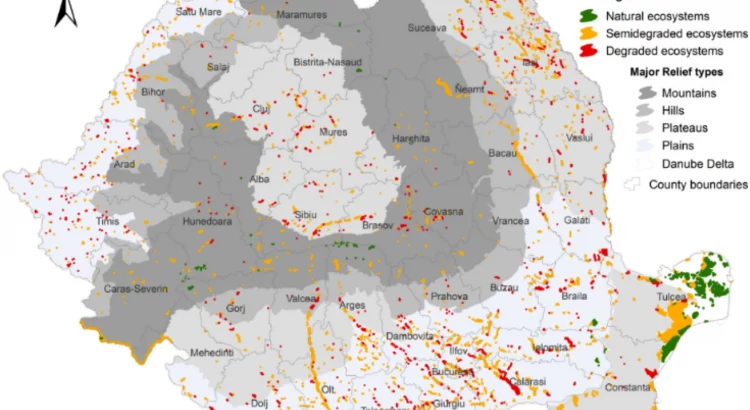
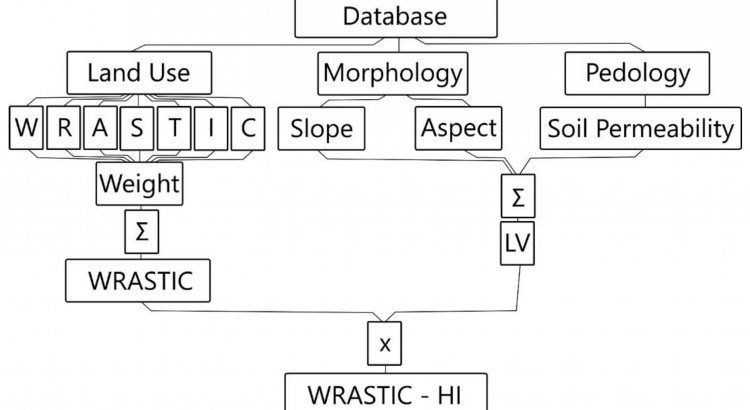
In general, the elaboration of the synthesis of water quality in Romania is based on the processing of a large volume of information coming from primary analytical data collected with a constant frequency by the organisms with a specific role in water quality monitoring. This study proposes a novel methodology for multi-criteria analysis aiming to evaluate the degradation state of lake ecosystems. The cornerstone of the newly presented methodology is a geographic information system (GIS) automated tool, involving the assessment of potential degradation sources affecting the watershed that supply the lakes with water. The methodology was tested by performing an analysis on 30 lakes in Romania. The lakes belong to different geographical areas, owing various natural specific conditions and were selected to fit to various types and specific local conditions. The calculation of the WRASTIC-HI (Wastewater–Recreation–Agriculture–Size–Transportation–Industry–Cover–Hazard Index) revealed that, out of 30 lake ecosystems selected as the case study, two lakes were fully degraded, 24 lakes were semi-degraded, and four were in a natural state. The four lakes characterised by a natural state are located in mountainous regions or in the Danube Delta. The results obtained on the selected lakes proved that the proposed index calculation corresponded in all case studies to the real field situation, highlighting thus the accuracy of the assessing process and increased advantages of the assessment’s automation. View Full-Text

Evaluation of the quality of lentic ecosystems in Romania by a GIS based WRASTIC model

Niculae, Mihaita-Iulian, Avram, Sorin, Corpade, Ana-Maria, Dedu, Silvia, Gheorghe, Carmen Adriana, Pascu, Ionut Silviu, Ontel, Irina, Rodino, Steliana

Scientific Reports volume 11, Article number: 5361 (2021)

https://doi.org/10.1038/s41598-021-84802-9

Abstract

Globally, ecosystems are constantly degrading as a result of pressures derived from human activities and climate change. For working towards the restoration of the natural balance, it is necessary to evaluate the deviations induced in the ecosystems, to identify where the changes took place, to know what is their amplitude and to decide where it is possible to get involved. Many aquatic ecosystems are depreciated and their restoration is often difficult. Development of appropriate assessment methodologies will improve the decision-making process in public policies for environmental protection and conservation of biodiversity. This study presents an assessment of the degradation level of lentic ecosystems in Romania, performed through a multi-criteria analysis. An extension of the WRASTIC index (Wastewater-Recreational-Agricultural-Size-Transportations-Indutrial-Cover) was generated, namely WRASTIC-HI. The new index was obtained by including values derived from the Potential Pollutant Load index. The analysis showed that 13% of the evaluated lakes are natural, 56.5% are semi-degraded and 30.5% are degraded. The proposed methodology allows to determine the spatial distribution of the degradation sources and to calculate the corresponding indicators. The results obtained provide a useful tool for diagnostic step that can be used as a cornerstone to further identification of environmental conflicts and proposals for improvement of the ecological status of the lentic ecosystems.

Spatio-temporal insights into microbiology of the freshwater-to-hypersaline, oxic-hypoxic-euxinic waters of Ursu Lake

Andreea Baricz, Cecilia Maria Chiriac, Adrian-Ștefan Andrei, Paul-Adrian Bulzu, Erika Andrea Levei, Oana Cadar, Karina Paula Battes, Mirela Cîmpean, Marin Șenilă, Adorján Cristea, Vasile Muntean, Mircea Alexe, Cristian Coman, Edina Kriszta Szekeres, Cosmin Ionel Sicora, Artur Ionescu, David Blain, William Kenneth O’Neill, Jessica Edwards, John Edward Hallsworth, Horia Leonard Banciu

Environmental Microbiology (2021) 23(7), 3523–3540

https://doi.org/10.1111/1462-2920.14909

Summary

Ursu Lake is located in the Middle Miocene salt deposit of Central Romania. It is stratified, and the water column has three distinct water masses: an upper freshwater-to-moderately saline stratum (0–3 m), an intermediate stratum exhibiting a steep halocline (3–3.5 m), and a lower hypersaline stratum (4 m and below) that is euxinic (i.e. anoxic and sulphidic). Recent studies have characterized the lake’s microbial taxonomy and given rise to intriguing ecological questions. Here, we explore whether the communities are dynamic or stable in relation to taxonomic composition, geochemistry, biophysics, and ecophysiological functions during the annual cycle. We found: (i) seasonally fluctuating, light-dependent communities in the upper layer (≥0.987–0.990 water-activity), a stable but phylogenetically diverse population of heterotrophs in the hypersaline stratum (water activities down to 0.762) and a persistent plate of green sulphur bacteria that connects these two (0.958–0.956 water activity) at 3–3.5 to 4 m; (ii) communities that might be involved in carbon- and sulphur-cycling between and within the lake’s three main water masses; (iii) uncultured lineages including Acetothermia (OP1), Cloacimonetes (WWE1), Marinimicrobia (SAR406), Omnitrophicaeota (OP3), Parcubacteria (OD1) and other Candidate Phyla Radiation bacteria, and SR1 in the hypersaline stratum (likely involved in the anaerobic steps of carbon- and sulphur-cycling); and (iv) that species richness and habitat stability are associated with high redox-potentials. Ursu Lake has a unique and complex ecology, at the same time exhibiting dynamic fluctuations and stability, and can be used as a modern analogue for ancient euxinic water bodies and comparator system for other stratified hypersaline systems.

Performing Democracy: An Analysis of Church-Based Electoral Capital in Romania

BÎRSĂNUC ELENA-MANUELA, Cocis Emanuela Adina, GLIGOR VIOREL, MAN TITUS-CRISTIAN, NICULA  ALEXANDRU – SABIN, STOICA  MIHNEA SIMION

April 2021 Transylvanian Review XXIX(2):291-309 DOI: 10.33993/TR.2020.suppl.2.18

Abstract

Confessional diversity triggers various social and political behaviors of citizens. In terms of the relation between politics and religion, Romania is both a diverse and a complex case study, as the church not only had a strong influence on the historical process of state formation, but still casts a long shadow on political decisions. Therefore, the current study aims to determine a connection between the monastics sites’ location and their influence on the political decisions of citizens, in two national elections that had a major impact on the recent political developments in the country: the 2016 Parliamentary elections and the 2018 Constitutional Referendum (on defining the ‘family’). The confessional and social discrepancies between Romania’s rural and urban areas lead to a comparative analysis of the votes on additional lists for the two events. Results indicate a different degree of clergy implication in the electoral process, depending on the impact of the political event on church reliability. Thus, Romania’s church-based electoral capital is assessed using spatial and statistical analysis, resulting territorial patterns based on voter turnout results.

A GIS-Based Spatial Analysis Model Approach for Identification of Optimal Hydrotechnical Solutions for Gully Erosion Stabilization. Case Study

Bilașco, Ș.; Roșca, S.; Vescan, I.; Fodorean, I.; Dohotar, V.; Sestras, P.

Appl. Sci. 2021, 11(11), 4847; https://doi.org/10.3390/app11114847
The accentuated degradation of agricultural lands as a result of deep erosion processes is the main problem identified in abandoned agricultural lands under the rainfall intensities, increasing number of hot days, indirectly under the impact processes derived from them (soil erosion, vegetation drying, etc.), as well as inadequate or poor management policies implemented by local authorities. The present study aims to develop and present a methodology based on GIS spatial analysis to choose the best hydro-amelioration solution for the arrangement of a complex ravine that negatively affects the entire agroecological area in its immediate vicinity. The proposed model is developed on spatial databases obtained based on UAV flights, the simulation of flow rate values and the establishment of three hydraulic analysis models through the HEC-RAS software with the main purpose of evaluating the results and databases, in order to identify the best implementing model for the stabilization and reduction in erosion within the analysed area. The comparative analysis of the three analysed scenarios highlighted the fact that a dam-type structure with overflow represents the best hydro-ameliorative solution to be implemented in the present study. The accuracy of the obtained results highlights the usefulness of developing GIS models of transdisciplinary spatial analysis to identify optimal solutions that can be implemented in territories with similar characteristics. View Full-Text

Geodetic and UAV Monitoring in the Sustainable Management of Shallow Landslides and Erosion of a Susceptible Urban Environment

by Sestras, P.; Bilașco, Ș.; Roșca, S.; Dudic, B.; Hysa, A.; Spalević, V.
Remote Sens. 2021, 13(3), 385; https://doi.org/10.3390/rs13030385
Landslides are a worldwide occurring hazard that can produce economic impact and even fatalities. The collection and monitoring of data regarding active landslides are important for predicting future landslides in that region, and is critical to minimize the losses caused. In the expanding metropolitan area of Cluj-Napoca, Romania, drastic changes of land use and increasement of construction zones represent a current evolution issue. The urban sprawl phenomenon imposed the expansion of the city limits and outside the old built-up area, and due to the hilly terrain and geomorphology, natural hazards such as landslides and erosion processes are susceptible to appearance or reactivation. The study incorporates interdisciplinary research composed of evaluation of a landslide susceptible hotspot located in an area of interest to the municipality by means of geodetic and topographic precise measurements, combined with the use of unmanned aerial vehicles (UAV) monitoring of surface movement and GIS spatial analysis. The data obtained in a span of over two years reveal that the investigated slope is subjected to a shallow active landslide of a few centimeters per year, and based on the 64 individual placed landmarks the highest displacement value was 67 mm. Through geomatic tools the exchange rate of the slope surface was evaluated with comprehensive volume calculations, such as displacement, erosion, and accumulation that illustrate a volume of material displaced of 107.2 m3 and the accumulated one of 55.7 m3. The results provide valuable insight into the complex landslide and erosion dynamics that are crucial when predicting future movements and prevention measures. View Full-Text

Indicator‐based assessment of local and regional progress toward the Sustainable Development Goals (SDGs): An integrated approach from Romania

First published: 04 March 2021

Funding information: Ministry of Research and Innovation CNCS-UEFISCDI, Grant/Award Number: project number PN-III-P4-ID-PCCF-2016-0084, within PNCDI III

Abstract

In order to measure progress in achieving the Sustainable Development Goals (SDGs) by 2030, 169 targets have been approved globally. Even though interest in implementing these goals is high, many states have not yet established a set of subnational indicators to measure the implementation of the SDGs and have not completed their own assessment of progress in achieving these global goals. This study aims to measure the progress toward achieving the SDG at local and regional level in Romania by calculating the SDG Index. For the calculation of the SDG Index at subnational level, we propose an integrated approach based on 90 indicators, stored and processed in a PostgreSQL object-relational database. The results show the concentration of the highest performances of sustainable development in some specific geographical areas. The rural areas and the extended peripheral regions in the eastern and southern part of the country are the poorest performers.