Multi-sensor remote sensing to map glacier debris cover in the Greater Caucasus, Georgia

Holobaca Iulian-Horea, Ivan Kinga, Alexe Mircea, Pop Olimpiu-Traian, Petrescu Sorin Hadrian, Elizbarashvili Mariam, Tielidze Levan, Germain Daniel, Gaprindashvili George

Journal of Glaciology, 67(264), 685-696. doi:10.1017/jog.2021.47

Abstract

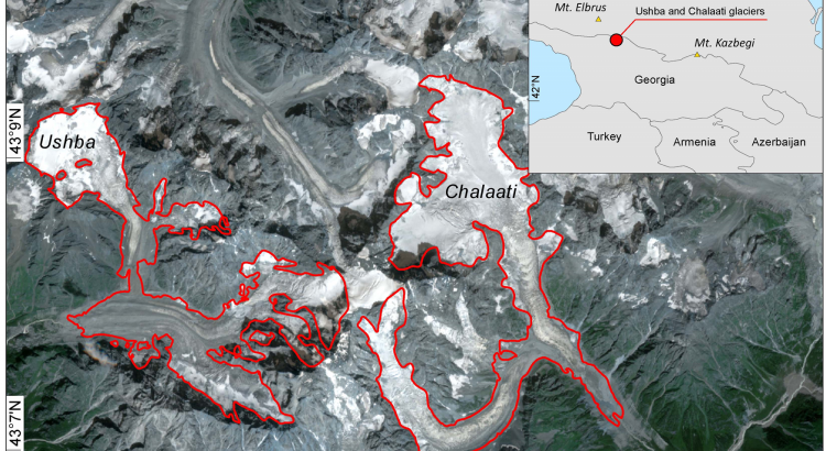
Global warming is causing glaciers in the Caucasus Mountains and around the world to lose mass at an accelerated pace. As a result of this rapid retreat, significant parts of the glacierized surface area can be covered with debris deposits, often making them indistinguishable from the surrounding land surface by optical remote-sensing systems. Here, we present the DebCovG-carto toolbox to delineate debris-covered and debris-free glacier surfaces from non-glacierized regions. The algorithm uses synthetic aperture radar-derived coherence images and the normalized difference snow index applied to optical satellite data. Validating the remotely-sensed boundaries of Ushba and Chalaati glaciers using field GPS data demonstrates that the use of pairs of Sentinel-1 images (2019) from identical ascending and descending orbits can substantially improve debris-covered glacier surface detection. The DebCovG-carto toolbox leverages multiple orbits to automate the mapping of debris-covered glacier surfaces. This new automatic method offers the possibility of quickly correcting glacier mapping errors caused by the presence of debris and makes automatic mapping of glacierized surfaces considerably faster than the use of other subjective methods.
Indicator-based assessment of local and regional progress toward the Sustainable Development Goals (SDGs): An integrated approach from Romania

József Benedek, Kinga Ivan, Ibolya Török, Arnold Temerdek, Iulian-Horia Holobâcă

Sustainable Development. 2021; 29: 860875. https://doi.org/10.1002/sd.2180

Abstract

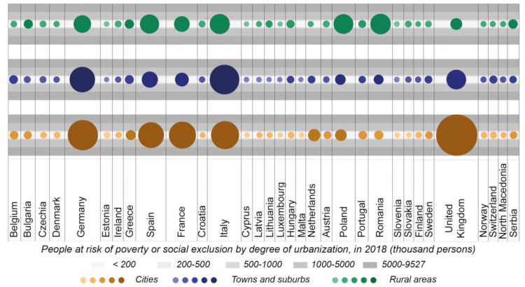
In order to measure progress in achieving the Sustainable Development Goals (SDGs) by 2030, 169 targets have been approved globally. Even though interest in implementing these goals is high, many states have not yet established a set of subnational indicators to measure the implementation of the SDGs and have not completed their own assessment of progress in achieving these global goals. This study aims to measure the progress toward achieving the SDG at local and regional level in Romania by calculating the SDG Index. For the calculation of the SDG Index at subnational level, we propose an integrated approach based on 90 indicators, stored and processed in a PostgreSQL object-relational database. The results show the concentration of the highest performances of sustainable development in some specific geographical areas. The rural areas and the extended peripheral regions in the eastern and southern part of the country are the poorest performers.

Climate change perception in Romania

Cheval Sorin , Bulai Ana, Croitoru Adina-Eliza, Stefan Dorondel, Micu Dana, Mihăilă Dumitru, Sfica Lucian, Tiscovschi Adrian

Abstract

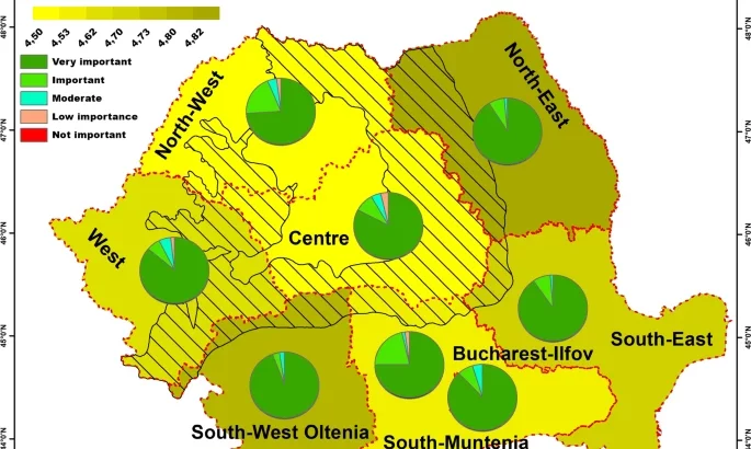
In the last decades, anthropogenic drivers have significantly influenced the natural climate variability of Earth’s atmosphere. Climate change has become a subject of major interest for different levels of our society, such as national governments, businesses, local administration, or citizens. While national and local policies propose mitigation and adaptation strategies for different sectors, public perception is a key component of any implementation plan. This study investigates the CC perception in Romania, based on a national-scale online survey performed in the spring of 2020, aiming to outline the prominence of environmental and CC issues, level of information and interest, perceived causes, changes perceived in meteorological phenomena at the regional scale, perceived impacts, and the psychological representation of the CC. The study investigates single causal factors of perception. We found that particularly (i) the regional differences on climate change intensity strongly bias the perception of CC causes; (ii) age is very likely to influence the acceptance of CC, the importance of environmental issues, and the levels of information and interest; while (iii) age, gender, and place of residence (rural–urban) are very likely to control the changes perceived in the occurrence of various meteorological phenomena, and their impact. This research is the first statistically relevant analysis (± 4%, statistical significance) developed at national and regional scales and the only study of climate change perception performed during the COVID-19 pandemic in Romania. Its results may represent the baseline for more in-depth research.

Flash Flood Risk Assessment and Mitigation in Digital-Era Governance Using Unmanned Aerial Vehicle and GIS Spatial Analyses Case Study: Small River Basins

Bilasco Stefan, Hognogi Gheorghe – Gavrila, Roşca Sanda-Maria, Pop Ana Maria, Vescan Iuliu, Fodorean Ioan, Marian-Potra Alexandra-Camelia, Sestras Paul

Remote Sens. 2022, 14(10), 2481; https://doi.org/10.3390/rs14102481

Abstract

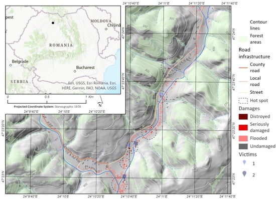
Watercourses act like a magnet for human communities and were always a deciding factor when choosing settlements. The reverse of these services is a potential hazard in the form of flash flooding, for which human society has various management strategies. These strategies prove to be increasingly necessary in the context of increased anthropic pressure on the floodable areas. One of these strategies, Strategic Flood Management (SFM), a continuous cycle of planning, acting, monitoring, reviewing and adapting, seems to have better chances to succeed than other previous strategies, in the context of the Digital-Era Governance (DEG). These derive, among others, from the technological and methodological advantages of DEG. Geographic Information Systems (GIS) and Unmanned Aerial Vehicles (UAV) stand out among the most revolutionary tools for data acquisition and processing of data in the last decade, both in qualitative and quantitative terms. In this context, this study presents a hybrid risk assessment methodology for buildings in case of floods. The methodology is based on detailed information on the terrestrial surface—digital surface model (DSM) and measurements of the last historical flash flood level (occurred on 20 June 2012)—that enabled post-flood peak discharge estimation. Based on this methodology, two other parameters were calculated together with water height (depth): shear stress and velocity. These calculations enabled the modelling of the hazard and risk map, taking into account the objective value of buildings. The two components were integrated in a portal available for the authorities and inhabitants. Both the methodology and the portal are perfectible, but the value of this material consists of the detailing and replicability potential of the data that can be made available to administration and local community. Conceptually, the following are relevant (a) the framing of the SFM concept in the DEG framework and (b) the possibility to highlight the involvement and contribution of the citizens in mapping the risks and their adaptation to climate changes. The subsequent version of the portal is thus improved by further contributions and the participatory approach of the citizens. View Full-Text

The Integrated Assessment of Degraded Tourist Geomorphosites to Develop Sustainable Tourism: A Case Study of Grădina Zmeilor Geomorphosite, North-West Region, Romania

Codrea Paula-Minerva, Bilasco Stefan, Roşca Sanda-Maria, Irimus Ioan-Aurel, Vescan Iuliu, Rusu Raularian, Fodorean Ioan, Sestras Paul,

Appl. Sci. 2022, 12(19), 9816; https://doi.org/10.3390/app12199816

Abstract

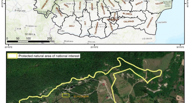
Most of the natural geomorphosites represent main attractions that have a high tourism potential and need great care in terms of their capitalization. The irrational tourism capitalization of the geomorphosites may lead to their degradation because of the lack of proper tourism infrastructure and the practice of random and uncontrolled tourism. The reintroduction in the tourism circuit of such geomorphological structures that have a high landscape and scientific value claims, first of all, the assessment of the current state of degradation and the drawing up of sustainable development proposals from a geomorphological point of view. This study deals mainly with the assessment of a geomorphosite (Grădina Zmeilor Geomorphosite, North-West Region, Romania), using a complex methodology, which is based on the identification of criteria influencing the tourism development of the geomorphosite, and their analysis by means of qualitative points given according to the impact of each criterion. A total of 17 criteria have been therefore identified. They are structured along four levels of analysis which are integrated in the form of spatial analysis based on weighted average, and highlight the overall value of the analysed geomorphosite. By implementing the methodology in the proposed research, a total value of 0.29 has been obtained in an interval between 0 and 1. This value underlines the high degree of degradation of the geomorphosite. The planning proposals have the main purpose of increasing the overall value of the geomorphosite by providing sustainability in its capitalization. To achieve this, proposals have been made to mitigate the shortcomings for a total of four criteria. The overall value of the geomorphosite has been recalculated, resulting a significant increase of the value (0.33), highlighting the impact of the implementation of these proposals in practice for the development of the geomorphosite and the increase of its level of tourism attractiveness. The introduction of this objective on the tourist map, following the application of the suggestions proposed in this paper, can lead to favorable economic development both at the local and regional level. This analysis model can also be applied to other geomorphists facing the problem of degradation and involution. View Full-Text

Increasing territorial planning activities through viewshed analysis

Hognogi, GG (Hognogi, Gheorghe-Gavrila) Pop, AM (Pop, Ana-Maria) Malaescu, S (Malaescu, Simona) Nistor, MM (Nistor, Margarit-Mircea)

Geocarto International, 37:2, 627-637, DOI: 10.1080/10106049.2020.1730450

Abstract

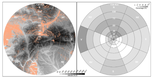
Visibility analyses are employed in various fields, from landscape to archeology or territorial planning. Two case studies, of different elevation, from Romania were selected to be considered for setting up some observation points as lookout points. Fuzzy viewshed analysis was performed to evaluate the degree of visibility of certain landscape components and was also used as a tool for territorial planning. The main results of the research were some particular viewshed analysis area according to the dominant visibility directions. This methodology may be useful to local authorities, which are the only responsible bodies for authorizing, creating and setting up lookout points in a given space or for organizing certain planning activities.

The impact of extreme temperatures on human mortality in the most populated cities of Romania

Andreea-Sabina Scripcă, Fiorella Acquaotta, Adina-Eliza Croitoru, Simona Fratianni

Int J Biometeorol (2021). https://doi.org/10.1007/s00484-021-02206-w

Abstract

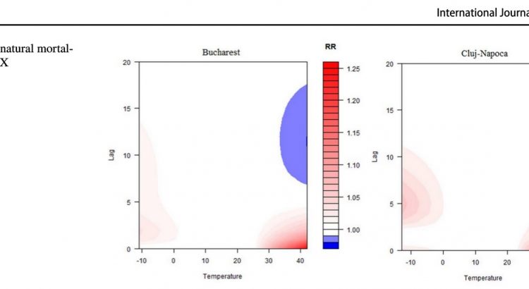
The impact of extreme weather conditions on humans is one of the most important topics in biometeorology studies. The main objective of this study is to analyze the relationship between temperature-related weather conditions and natural mortality in the five most populated cities of Romania, namely, Bucharest, Cluj-Napoca, Constanța, Iași, and Timișoara. The results of this study aim to bridge a gap in national research. In the present paper, we used daily natural mortality data and daily minimum and maximum air temperatures. The distributed lag nonlinear model (DLNM) allowed us to identify weather conditions associated with natural mortality. The most important results are as follows: (i) a higher daily mortality is related to a high frequency of heat stress conditions; (ii) a higher maximum temperature increases the relative risk (RR) of natural mortality; (iii) the maximum number of fatalities is recorded on the first day of high-temperature events; and (iv) individuals much more easily adapt to cold stress conditions. The main conclusion in this study is that the inhabitants of the most populated cities in Romania are more sensitive to high-temperature stress than to low-temperature stress.

Keywords Extreme temperature· Natural mortality· Relative risk· Bioclimatic stress· Romania

Tree ring archives of debris flow contamination in a post-mined area: Combined dendroecological research

Radek Tichavský, Olimpiu Traian Pop, Martin Mihaljevič, Karel Šilhán, Lenka Vondrovicová

CATENA, Volume 207, 2021, 105595, ISSN 0341-8162,
https://doi.org/10.1016/j.catena.2021.105595

Abstract

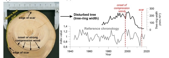
The degradation of forest ecosystems represents a severe environmental issue in anthropogenically modified landscapes worldwide. We demonstrated the negative impact of contaminated debris flow deposits on riparian forest in the Romanian Carpathians through the innovative combination of several dendroecological approaches. Reconstruction of debris flow activity using 95 individuals of Picea abies (L.) Karst. was performed to identify 11 events during the period 1952–2018. Recent events (e.g., 2007, 2014, 2016–2017) filled the valley floor after the stream was dammed in the 1980s, which deteriorated tree growth. This state was worsened by site acidity (pH = 3.8), low organic carbon, high sulfur content, and high concentrations of several metals in debris flow deposits. Wood anatomical analyses confirmed that trees producing tangential rows of traumatic resin ducts as a possible response to burial by toxic debris material subsequently produced smaller and flatter earlywood tracheids. In particular, the most obvious changes (average decrease in tracheid lumen area by 62.9% over two years) occurred after the 2016 debris flow event. Using inductively coupled plasma optical emission and/or mass spectrometry, we identified peak or increased concentrations of thallium (max. 0.7 mg kg−1), caesium (max. 0.4 mg kg−1), and aluminium (max. 434 mg kg−1) in tree biomass that could be related to debris flow activity in 1996, 2007, and 2016. Regarding the individual-specific responses of sampled trees, we conclude that the forest decline is caused by complex interaction between the depth of tree burial by debris flow deposits, the mechanical weight and chemistry of deposits, and the rate of nutrient and toxic element uptake.

Keywords

Debris flow, Dendrogeomorphology, Wood anatomy, Dendrochemistry, Post-mined area

Faces of Marginal Housing in Romania

Hognogi G-G, Pop A-M, Marian-Potra A-C.

Sustainability 2021, 13(7), 3983;
Marginal settlements may be defined as inhabited areas characterized by a series of negative features, typicallyethnic segregation, social discrimination, poor living conditions and conflicts, with impact on their dwellers and neighboring communities. In Romania, informal settlements were legislated in 2019; it subsequently became mandatory for the local authorities to spatially delimit them and formulate measures to improve living conditions. However, there are still numerous issues to be solved, from the lack of basic services (health, education) to the persistent poor living conditions or serious environmental problems. The Roma communities selected for our study are no exception. They are located on the outskirts of some cities or in their historical centers (Cluj-Napoca, Sibiu, Timișoara, Baia Mare). Through content analysis, based on print and electronic media from the last 10 years (n = 150 news items), different aspects of marginal housing were illustrated. The results of the study revealed some particular aspects, namely: some of the Roma communities are relocated whilst some others are subject to environmental conflicts; funding addressing the quality of life of Roma ethnics seems to deepen the phenomenon of segregation among communities, most of the measures being limited to the creation of housing facilities.

Importance of watermills for the Romanian local community

Gheorghe-Gavrilă Hognogi, Alexandra-Camelia Marian-Potra, Ana-Maria Pop, Simona Mălăescu

Journal of Rural Studies, Volume 86, 2021, Pages 198-207, ISSN 0743-0167,

https://doi.org/10.1016/j.jrurstud.2021.05.031.

Abstract

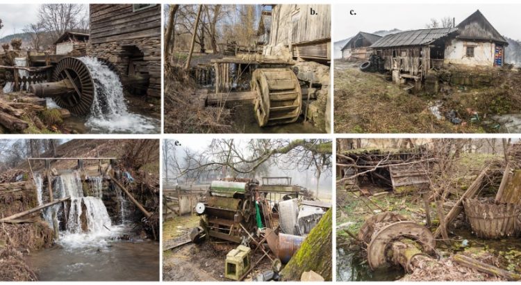
This study identifies the potential interrelations between nostalgia, experiential tourism and watermill heritage and its implications for the local community. The study area is represented by the catchment area of the Someșul Mare River (Romania). Some 15 semi-structured interviews were carried out attempting to grasp the perception of the local community on the role played by mills in the 18th-20th centuries, namely to show their polarization and social functions. The interviews were supplemented by 10 observation sheets filled out in the field. These contain information on the current state of the mills, the items being focused on the following aspects: type and dynamics of ownership, current use, structure of water-powered facilities, polarization area, and age. Results showed that some functional mills still exist and could be subject to investments for tourism purposes. The importance of mills for the local community stems both from the stories of the former millers or their customers and also by considering the significant number of working mills during the 18th – 20th centuries, which were cartographically reconstructed in this paper. If nostalgia can become a standalone resource in individualizing a particular tourism type, we may conclude that the watermill heritage, by all its attributes, provides strong heritage tourism potential.

Keywords: Heritage-led regeneration; Local communities; Nostalgia; Cultural heritage; Watermills; Romania