Bilasco Stefan, Hognogi Gheorghe – Gavrila, Roşca Sanda-Maria, Pop Ana Maria, Vescan Iuliu, Fodorean Ioan, Marian-Potra Alexandra-Camelia, Sestras Paul
Remote Sens. 2022, 14(10), 2481; https://doi.org/10.3390/rs14102481
Abstract
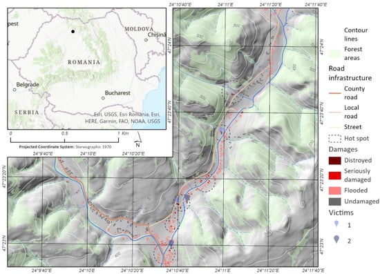
Watercourses act like a magnet for human communities and were always a deciding factor when choosing settlements. The reverse of these services is a potential hazard in the form of flash flooding, for which human society has various management strategies. These strategies prove to be increasingly necessary in the context of increased anthropic pressure on the floodable areas. One of these strategies, Strategic Flood Management (SFM), a continuous cycle of planning, acting, monitoring, reviewing and adapting, seems to have better chances to succeed than other previous strategies, in the context of the Digital-Era Governance (DEG). These derive, among others, from the technological and methodological advantages of DEG. Geographic Information Systems (GIS) and Unmanned Aerial Vehicles (UAV) stand out among the most revolutionary tools for data acquisition and processing of data in the last decade, both in qualitative and quantitative terms. In this context, this study presents a hybrid risk assessment methodology for buildings in case of floods. The methodology is based on detailed information on the terrestrial surface—digital surface model (DSM) and measurements of the last historical flash flood level (occurred on 20 June 2012)—that enabled post-flood peak discharge estimation. Based on this methodology, two other parameters were calculated together with water height (depth): shear stress and velocity. These calculations enabled the modelling of the hazard and risk map, taking into account the objective value of buildings. The two components were integrated in a portal available for the authorities and inhabitants. Both the methodology and the portal are perfectible, but the value of this material consists of the detailing and replicability potential of the data that can be made available to administration and local community. Conceptually, the following are relevant (a) the framing of the SFM concept in the DEG framework and (b) the possibility to highlight the involvement and contribution of the citizens in mapping the risks and their adaptation to climate changes. The subsequent version of the portal is thus improved by further contributions and the participatory approach of the citizens. View Full-Text