Holobaca Iulian-Horea, Ivan Kinga, Alexe Mircea, Pop Olimpiu-Traian, Petrescu Sorin Hadrian, Elizbarashvili Mariam, Tielidze Levan, Germain Daniel, Gaprindashvili George
Journal of Glaciology, 67(264), 685-696. doi:10.1017/jog.2021.47
Abstract
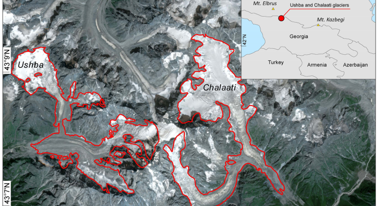
Global warming is causing glaciers in the Caucasus Mountains and around the world to lose mass at an accelerated pace. As a result of this rapid retreat, significant parts of the glacierized surface area can be covered with debris deposits, often making them indistinguishable from the surrounding land surface by optical remote-sensing systems. Here, we present the DebCovG-carto toolbox to delineate debris-covered and debris-free glacier surfaces from non-glacierized regions. The algorithm uses synthetic aperture radar-derived coherence images and the normalized difference snow index applied to optical satellite data. Validating the remotely-sensed boundaries of Ushba and Chalaati glaciers using field GPS data demonstrates that the use of pairs of Sentinel-1 images (2019) from identical ascending and descending orbits can substantially improve debris-covered glacier surface detection. The DebCovG-carto toolbox leverages multiple orbits to automate the mapping of debris-covered glacier surfaces. This new automatic method offers the possibility of quickly correcting glacier mapping errors caused by the presence of debris and makes automatic mapping of glacierized surfaces considerably faster than the use of other subjective methods.